Francis Tuttle Technology Center in Oklahoma is a public technology center providing career and technical education to both high school students and adults, with a focus on preparing people for the modern workforce. Francis Tuttle offers a variety of programs in areas such as information technology, health sciences, manufacturing, engineering and transportation, among others. The center is known for its strong partnerships with local businesses and industries, which helps to ensure that its programs are relevant and aligned with the needs of the local job market. They also offer a range of support services, such as career counseling and job placement assistance, to help students achieve their career goals.
Francis Tuttle has four locations in and around Oklahoma City, and they wanted to improve the visitor experience by making it easier for students and visitors to navigate the grounds of their Rockwell and Danforth campuses. The Center also hosts events, so a directory of things happening on site, and wayfinding for those events, would also be welcome. Since Francis Tuttle already uses AxisTV Signage Suite for their visual communications, they asked Visix to create a custom interactive wayfinding project that combines campus and building maps with directories for people, places and events.
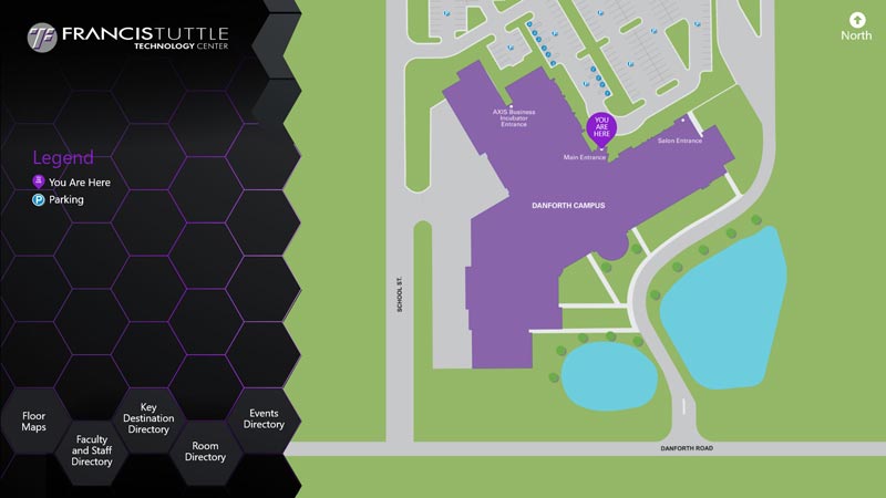
The touchscreen wayfinding shows on 13 displays on two campuses, and is designed in a stunning flat art style using a honeycomb graphic scheme with the school’s colors of purple and gold on black for high contrast and readability. The screen defaults to a bird’s-eye view of the campus shown in relation to nearby streets and parking, as well as “you are here” indicators for the particular kiosk where the wayfinding is being used. When the screen isn’t in use, it times out back to the campus map automatically to present a fresh starting point for the next visitor.
Users can choose from five buttons, depending on their need: floor maps, faculty and staff directory, key destination directory, room directory and events directory. This allows people to search for information with whatever information they have, in the way they prefer. All interactivity throughout the project is at the bottom of the screen for ADA compliance.
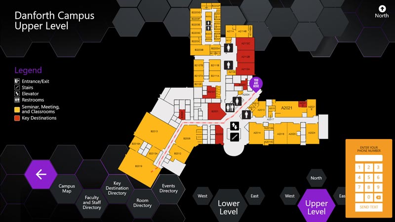
Floor maps show a “You Are Here” indicator and maps of both the upper and lower levels of the building. To help visitors orient themselves quickly, there are buttons to zoom in on North, West and East subsections of each floor. Seminar, meeting and classrooms are shown in gold, while key destinations are shown in red, and icons point out common points like restrooms, stairs, elevators and exits.
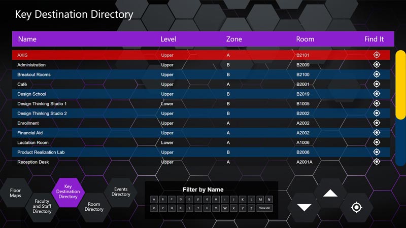
All four directories are structured similarly, with a table of destinations and details that can be scrolled through using a scrollbar or buttons at the bottom of the screen. Each directory also has additional filters available for more in-depth search functionality.
“Find It” buttons for each directory item and at the bottom of the screen launch an animated path on floor maps from the display to the intended destination. If the destination is on a different floor, the path guides users to elevators, then shows the path continuing on the other floor. Once the destination has been mapped, users can enter their phone number in an onscreen keypad to receive turn-by-turn directions via text message.
The faculty and staff directory lists contacts alphabetically by last name and can be filtered by the first letter of the last name as well. Visitors can see the person’s first name, department, building, which level of which building they’re on, and their room number.
The key destinations directory includes places like student services, administration, financial aid, the testing center, the design school, the café and even a lactation room. The list shows the destination, level, zone and room, and can be filtered by the first letter of the location name for even faster information.
The room directory shows room number, room name, zone and level. Users can sort the list by each of those fields using additional touchscreen controls.
All of the information populating these three directories is being pulled from a custom-built database with a user-friendly web user interface built by Visix. This lets the school quickly add or alter information in the database and it revises automatically in the wayfinding project – making all directory updates easy and efficient.
The events directory pulls its information from the school’s EMS calendar to show event name, start and end times, building and room for each event scheduled that day on campus. The list can be sorted by any of those fields using additional controls at the bottom of the screen, and of course, includes the “Find It” mapping feature with SMS integration.
Despite containing a vast amount of information, the interactive wayfinding developed by Visix for Francis Tuttle Technology Center feels neither cluttered nor confusing. The design is visually appealing, and the interface is intuitive to navigate, making it easy for visitors to find the information they need. Features like auto-updating databases and SMS directions provide convenience not only for the people using the wayfinding but also for those maintaining it.
Overall, Visix wayfinding has significantly improved the visitor experience at Francis Tuttle Technology Center, demonstrating how technology can enhance and modernize educational institutions.